Explore the moors: Cornwall’s best kept secret!

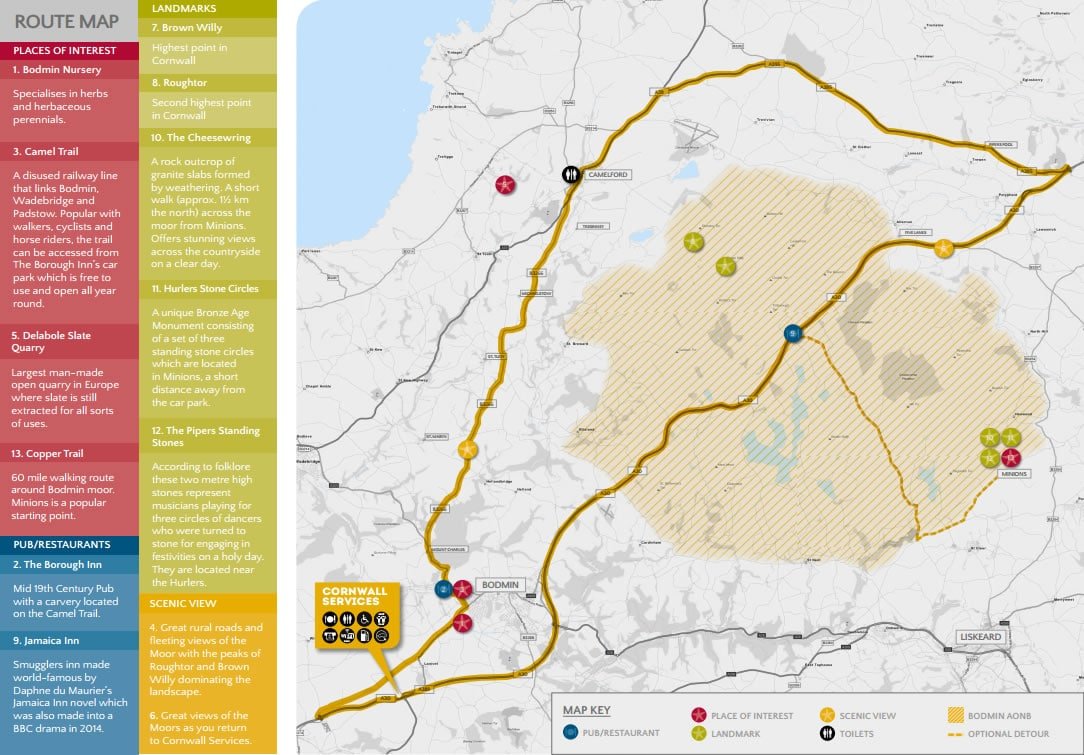
Bodmin Moor is one of Cornwall’s best kept secrets. It covers an area of 150 square miles and is a fantastic place for all ages and abilities to explore. It was once the heart of Cornwall’s tin mining industry and is steeped in history with ancient buildings, standing stones and medieval farms. It is also home to two of the highest peaks in Cornwall and the famous Copper Trail, a walking route which extends almost 60 miles around Bodmin Moor taking in the beautiful landscapes, lakes and ancient landmarks.
Here at Cornwall Services we have hand-picked a driving route which takes in the moors and some breathtaking scenery and includes some interesting places to visit on your way!
Directions:
TIME APPROXIMATELY 2 HOURS (NO STOPS)
From Cornwall Services turn right at the roundabout, go across the bridge
and then take the first exit onto the Old Coach Road; this joins the A389
Truro Road which continues towards Bodmin.
- Take a left towards Wadebridge about half a mile past Bodmin Nursery;
follow this road until you hit a T junction and turn left down the hill, crossing an old train line with a distinctive bump in the road. - Continue up the hill and take the right signposted the B3266 to Camelford.
From this point you are approaching Bodmin Moor. - Follow the B3266 all the way to Camelford then join the A39
towards Bude. - Take a right at the A395 towards the A30. At the A30, take the
exit marked Bodmin and head back towards Cornwall Services.
Explore the Roseland Peninsula

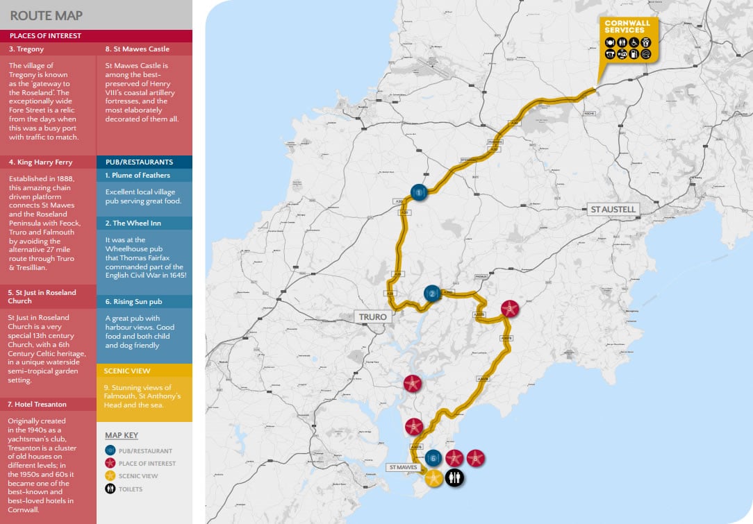
In our opinion, this is one of Cornwall ’s best driving roads out of the busy tourist season!
Bordered by the Fal Estuary to the west and the Atlantic to the east, The Roseland Peninsula has been designated part of Cornwall’s Area of Outstanding Natural Beauty for the quality of its landscape and coastal scenery.
It’s only a short drive from Cornwall Services before you hit a switchback of lanes that will lead you to some lovely wide open beaches that are never crowded; out of the way farm shops selling produce grown in nearby fields and ultimately to the coast and St Mawes, a fashionable fishing village curving around a sheltered bay.
The peninsula also has great walking routes and the coastal waters are popular with yachtsmen, windsurfers and canoeists.
Directions:
TIME APPROXIMATELY 1.5 HOURS IN TOTAL (STOP AT ST MAWES)
- From the Services, head South down the A30 towards Truro.
- Take a left at Carland Cross (Shell garage on your left) down the A39, past a Honda garage and towards the top of Truro.
- Turn left at the large T junction towards Tresillian.
- Now continue on the A390, up the long hill until you see a right turn for St Mawes/A3078.
Explore Poldark Country

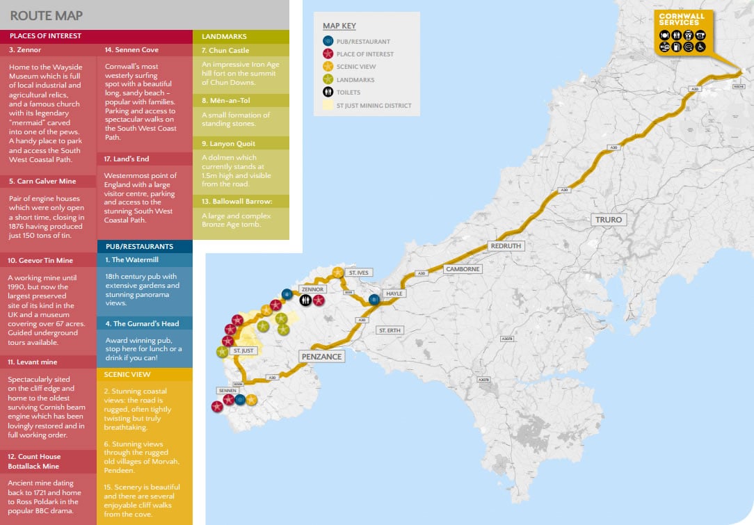
West Cornwall’s WILD, RUGGED LANDSCAPE and STUNNING SCENERY is popular with tourists and this dramatic setting has inspired generations of artists and writers. The old Cornish name for the area is Penwith, which means the headland at the end. It boasts a MAGNIFICENT STRETCH of the SOUTH WEST COASTAL PATH a must for any keen walker.
The area is STEEPED IN ANCIENT HISTORY, with the highest concentration of ancient sites found in Western Europe. The landscape was transformed in the 18th and early 19th centuries due to the rapid growth of copper and tin mining and several iconic clifftop engine houses still stand today. This area is part of the CORNISH MINING WORLD HERITAGE SITE, which gained its status in 2006.
Levant and Count House Bottallack Mine are the setting for the popular BBC One drama, Poldark, which is based on the books by Winston Graham.
Directions:
TIME APPROXIMATELY 2.75 HOURS (NO STOPS)
- From the Services, take the A30 south to St Ives roundabout
- Take the second exit on to Nut Lane towards St Ives
- At the second roundabout turn left on to Mill Hill
- Follow Mill Hill to the end and turn right onto the B3311 towards St Ives
- At the end of the road turn left on to the B3306 towards Zennor
- Follow the B3306 all the way to the A30 near Sennen and turn right
- Follow the A30 and then turn right into Sennen
- Return to the services by heading north on the A30
Explore North Cornwall
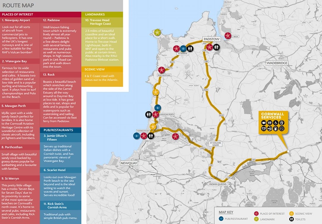
North Cornwall is renowned for its SPECTACULAR RUGGED COASTLINE, PICTURESQUE HARBOURS and some of the FINEST BEACHES IN THE COUNTRY! An AREA OF OUTSTANDING NATURAL BEAUTY, it has GREAT SURF and is a very popular tourist destination.

Directions:
TIME APPROXIMATELY 1 HOUR 10 MINUTES (NO STOPS)
- From the Services, take the A30 south to Highgate Hill junction
- Take the third exit on to the A39 and follow for approx. 2.5 miles
- At the roundabout take the first exit onto the A3059 towards Newquay
- Take the first right after Westways Filling Station and follow the wooded
road past Newquay Airport - At the end of the road turn left on to the B3276 and follow into
Watergate Bay - Turn right up Trevarrian Hill and stay on B3276 to Padstow
- The B3276 turns into the A389
• Follow A389, which then becomes the B3274, to Winnard’s Perch - For the services take the third exit on to the A39 and then the A30 north


